>>> Click here to access this episode of the Syllab Podcast on Spotify <<<
a) Relevance of geology
The first series was dedicated to the building blocks of matter and life together with the concept and forms of energy. In the second series we followed the rise in complexity order from the cells, a foundational unit of biological life, all the way to the elaborate and interconnected systems ensuring the homeostasis, survival, replication and thriving of a species like ours. In many ways, it is truly baffling such a construct could develop, purely on the back of physics, chemistry and evolutionary pressure. Not quite as complex, but equally stunning, are the non-biological products of the fundamental interactions and elementary constituents of matter that have combined and aggregated, and continue to do so, to form the entire content of our universe.
This will be the overarching topic of this third series and, if we are to make sense of it, we will again need to slowly make our way up the complexity order, starting with planetary sciences followed by the understanding of stars and the systems they command before graduating to galaxies and attempting to understand the whole of the universe, including its history and perhaps even its future…
Like biology, astronomical objects are a form of emerging property of forces and matter and so, like biology, even if some of them could be predicted theoretically, it is often easier and much more accurate to rely on observation. Hence, it is only natural to start our quest by looking around or rather below us and garner as much information as we can about our own planet, we call Earth, to help us model the typical genesis of planets and their inner workings. This first chapter on geology will focus on the body of Earth itself whereas Chapter 2 will explore a defining feature of our blue planet: its various bodies of water known together as the hydrosphere that have been indispensable to the emergence of organic life. In Chapter 3, our attention will shift to the various gaseous layers surrounding Earth called the atmosphere as well as to a macro phenomenon, a product of the interaction of geology, the hydrosphere, the atmosphere, and the Sun to produce what we know as our day-to-day weather and longer-term climate.
The Encyclopedia Brittanica introduces geology as “the field of studies concerned with the solid Earth. Included are sciences such as mineralogy, geodesy, and stratigraphy”. In turn, these cover the chemistry and properties of minerals, the geometry and orientation of the Earth, and the layering of rocks. The importance of these, beyond serving as a model on which to extrapolate the birth and properties of other planets elsewhere in the universe, should not be underestimated. Understanding the surface, near-surface and inner layers of the planet we call home allows us to extract information from the rock and sedimentary record, it makes us increasingly proficient at exploring for and extracting hydrocarbons and raw materials, and it underpins our improving ability to warn about impeding earthquakes and volcanic eruptions.
b) What and how can we tell?
By gaining a comprehensive picture of Earth as it is today, peering into its past and, by devising and calibrating models enabling us to model its evolution from the time of creation to its current state, we are able to extrapolate from those models to predict short term events and our long term future, obtain useful knowledge about the environment that would have existed at various stages of the development of organic life and make predictions about the formation and fate of planets within or outside of our own solar system, including the likelihood they may harbour simple or perhaps even intelligent life.
This is tantalizing, nevertheless gathering the required information is often a painstaking process or calls for advanced technologies, or both though direct observation of rocks and topographical features in various parts of the globe do also provide useful data and were the initial method of deriving geological knowledge – one we still use to this day.
If we are to think it through, what type of data is available to our senses and direct measurement? The first category certainly relates to the nature of our planet’s body, not its structure but its composition, and in particular the combination of chemical elements within it. The second category pertains to the structure of these elements, from a micro to a macro level, from the atomic and molecular arrangements to the various layers beneath our feet and down to the very centre of mass of the planet. The third deals with the shape and evolution of the surface layers over time since it is at the interfaces between the lithosphere, the hydrosphere and our atmosphere that complexity took another leap forward with the development of biological systems.
On one hand, applying chemical analysis to rock samples enables scientists to understand the make-up in terms of chemical elements and imaging techniques such as X-ray scattering or X-ray crystallography allows for the observation of the inner structure of those compounds, the understanding of their interatomic arrangements. With this information, it is possible to infer the various properties of rocks and other compounds found within the planet such as their hardness, ability to withstand pressure, their melting point, density and ferromagnetic attributes (or not).
On the other hand, understanding the macro makeup of Earth is more of a deductive process, using geochemical information and observations relating to seismic wave propagation and other seismologic techniques, the intensity and movements of the magnetic field, and its three-dimensional shape – this list is obviously not exhaustive. The trick is to develop a model of Earth’s body based on the laws of physics (and consequently of chemistry as well) which, when back-tested, best fit the observations.
A word here on the shape of the Earth. I had not realized it until recently but geodesy is a genuinely interesting branch of science that focuses on the measurement and representation of the planet as a shape and surface. There is more than meets the eye, literally, because to achieve high accuracy, factors such as the Earth’s rotation and local gravity need to be considered. The most useful output is arguably topographical maps and nowadays a lot of this measurement can be carried out by satellites, yet it was not always like this. To get some insight into the importance and methods of geodesy, I strongly recommend a read of The Great Arc: The Dramatic Tale of How India was Mapped and Everest was Named, a book written by John Keay. You will learn about scientific instruments of the time, the importance of plumb lines and light refraction, team dynamics, and the fact that since the Earth is an oblate spheroid, Mount Everest might be the highest mountain above sea level but Chimborazo, just 01°28′ south of the equator in Ecuador, is the point on the Earth’s surface that is the furthest away from its centre (6,384.4km Vs 6,382.3km).
Finally, the analysis of sedimentary rocks, those formed by the accumulation of both mineral and organic particles over time, provides clues as to their original location and their age. Since these sedimentary rocks are sometimes the repository of fossils, they serve as an evolutionary record of life on Earth.
How do we date rocks and fossils you may ask? There are two concepts to bear in mind: relative age and absolute age. The age of fossils is first correlated relative to the age of the layers of sedimentary rocks it is buried in and beneath. As the layers deposit, they do so horizontally and one upon the other with the newer layer covering the previous one. You would have noted the striated look of some rocks; this is the reason for this feature and knowing the age of one layer provides the means of deducting that of the other ones. As for absolute age, there are two key techniques.
The one you might be most familiar with is radiometric decay and for organic material it would specifically rely on carbon-14 decay rate – to know more about radioactive decay and half-life you may want to refer to S1 Section 7.c.
The second technique, less known outside the field of Earth’s science, is called “paleo-magnetism” and consists in working out the age of the rocks by analysing the orientation of the magnetic minerals embedded in those rocks. By checking the known or estimated positions of the magnetic poles throughout our planet’s history it is possible to derive a date range for those rocks as well. This was alluded to in S1 Section 8.f on the Magnetic North. This begs the question of our means of knowing the location of the magnetic poles and date of magnetic reversals (a cyclic event when both poles switch side over the course of a few thousand years), which partially relies on knowing the age of some rock layers so there is some iterative process required but having the correct data for one location clearly allows this datapoint to be leveraged for other locations.
c) Composition of Earth
Time to get a little more descriptive about the make-up of Earth, always with an eye on understanding how this explains various important phenomena. We’ll start with the core and radiate outward, all the way to the lithosphere which will provide the perfect springboard to look into continental plates and more broadly plate tectonics in the next section.
The broadest, high-level description distinguishes the core, the mantle and the crust but if there is some degree of chemical uniformity within each of those three regions, this description belies marked differences in dynamics so we’ll need to be a little more granular and subdivide the core into inner and outer cores, and the mantle into the lower and upper mantle areas. I have been using the term of lithosphere a few times until now and it refers to the top part of the upper mantle plus the crust with the interface between those being called the asthenosphere – it is called thus because it is ductile and “asthenos” in ancient Greek means “without strength”.
- The inner core is solid and, according to the current scientific knowledge, it consists of mostly iron (85%) and nickel. Pression there is intense and so are temperatures, reaching 7,000 °C. And yes, solids can be this hot at such pressure levels since inter-atomic distances are being compressed and kinetic forces do not get the better of them to create phase transitions into other states of matter such as liquids or gases. The heat is a byproduct of radioactive decay of the Fe and Ni chemical elements and it propagates by conduction to the outer core.
- After the first 1220km or so of the inner core comes the 2260 km of the outer core also comprising mostly of iron and nickel although in liquid form this time. This liquid state of ferromagnetic materials coupled with the rotation of the Earth around its axis creates currents propagating heat to the mantle by convection, which generates the Earth’s magnetic field. Altogether, the core only represents about 15% of the total volume of the planet.
- Around 2700 to 2900km below the surface of the Earth, the outer core transitions to the lower mantle which is composed mostly of silicate minerals so the preponderant elements are Magnesium (Mg), Iron (Fe), Calcium, Silicon (Si) and Oxygen (O). The boundary with the upper mantle occurs at around 670km beneath the surface and forms a discontinuity due to the change in structure of the mantle content, itself the result of atomic rearrangements as the pressure increases. This boundary sees a marked differential in the velocity of seismic waves with refraction, reflection and change in speed all taking place. The speed at which seismic waves travel increases with pressure (and therefore, all else being equal, with depth) but decreases with temperature. Waves can be compressional waves (“P waves”) and move through liquids, solids and gases or shear waves (“S waves”) and only travel through solid. This should ring a bell if you have read S2 Section 9.a. on sound waves, a type of compression wave, which also mentioned transverse waves. Measuring the way in which the P and S waves propagate provides great insights on the nature and structure of the Earth’s body.
- Above the 670km mark, the upper mantle starts and exhibits a temperature gradient from about 930 °C down to 230 °C at the asthenosphere. The most interesting aspect of the mantle is that although technically a solid, it behaves like a viscous fluid over long periods of times which allows for the following cycle to take place by convection: warmer material from the lower mantle expands and slowly rises to the surface (because it is more buoyant) and cools down as it reaches the boundary with the crust, at which point it becomes less buoyant and sinks back down through the mantle all the way to a layer near the core. And so on. This convection is the medium for heat dispersion and also creates the currents responsible for the movements of the elements forming the crust. Overall, the mantle accounts for 84% of the Earth’s volume with the remaining 1% available for the crust after deducting for the proportion of the core.
- The crust floats or rides, depending on one’s perspective, above the upper mantle. In the case of the continental crust, these areas with the surface emerging out of the oceans and the near-shore seabed representing about 41% of the planet’s surface, the chemical composition shows an increased presence of aluminium silicate, less density than the mantle and thickness varying between 25 and 70kms. In comparison, the oceanic crust is richer in magnesium and iron, has a density between that of the mantle and the continental crust and a thickness of under 10km on average.
At the surface, rocks also have their own type of cycle, one partially analogous to that of the mantle. Initially, they originated from the cooling of the molten part of the asthenosphere called magma, including when ejected out of volcanoes in the form of lava. This type of magmatic rock is more commonly called igneous rock and, through the combined effect of pressure and temperature, it can be transformed into other types of solids with different structure or composition called metamorphic rocks, an example of which would be marble. Through processes such as erosion and the dissolution of igneous and metamorphic rocks occurring at the surface, the particles called sediments accumulate and are cemented together through the addition of ions present in groundwater to form new rocks called sedimentary rocks.
d) Plate tectonics
Once we know about the mantle convection and relative thinness of the oceanic parts of the crust, it stands to reason the ongoing displacement of molten materials in the topmost portion of the upper mantle will exert push and pull forces across the crust, ultimately fracturing it into irregular sections. We call these tectonic plates and they come in different shapes, sizes and move in different directions at a rate of anywhere between 1cm and 16cm per year, essentially partially sinking into the ductile asthenosphere and riding the currents of the mantle.
This movement has been unceasing for at least 3 billion years and at times the plates end up merging back into what we dub supercontinents before splitting again in pieces. At the moment there are 16 principal plates illustrated in Figure 1 below, which also show the zones of subduction (blue and purple lines), divergence and transformation.
Figure 1: Current tectonic plates on Earth
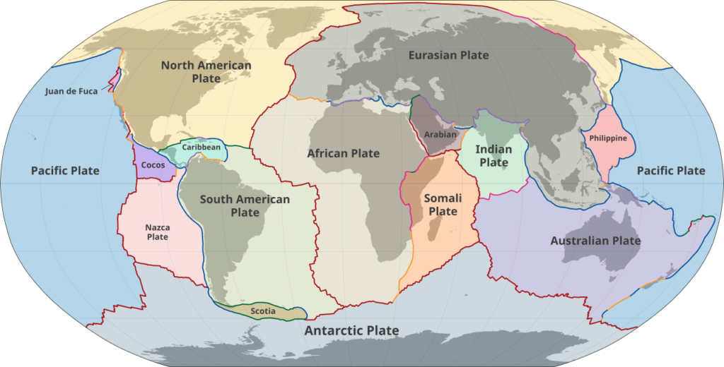
Credit: M. Bitton (CC BY-SA 3.0)
These three terms reflect the possible types of relative movements occurring at the boundary of plates, also called faults.
- A sideways or horizontal translation is called transform fault and results in no creation or disappearance of plate. This type of fault lines are regularly the epicentres of earthquakes as those experienced in Turkey and California can attest.
- When plates move apart, this is called divergence and it produces rift valleys as in the mid-Atlantic Ridge on the seafloor of the namesake ocean or the East African Rift which is slowly pulling Africa apart.
- The most active and destructive interface however is when plates converge and either collide, pushing each other to form mountain ranges such as the Himalayas where the Indian plate meets the Eurasian one, or one is forced to slide beneath the other, creating a zone of subduction featuring ocean trenches that are volcanically very active and earthquake-prone as is the case in the Pacific Ring of Fire.
The conclusion from this should be clear: Earth is a complex entity. Not alive according to biological definitions but clearly it offers a varied and evolving environment, and it has done so for many hundreds of millions of years. Time to go down Earth’s memory lane.
e) Earth: a brief geological history
The first several hundred millions years of our planet have been called the Hadean Eon, fittingly so given how turbulent this infancy has been. An eon is a geochronologic time unit spanning a fraction to a couple of a billion years and Hades was the mythological god of the dead, ruling over the underworld in Greek mythology. During this eon which started around 4.6 billion years ago and corresponds to the formation of the overall solar system, the current prevalent theory is that Earth and other planets formed by accreting gas and dust, growing as their gravity increased over time. This would have seen high level of volcanism, the creation of the oceans and outgassing (including water vapor) creating the primordial atmosphere and oceans.
Strictly speaking, the Hadean Eon is not part of the Earth’s geological time scale (GTS) because no rock from that time has survived in the geological record, meaning they all eventually melted again. So the GTS formally starts with the Archean Eon, from about 4.0 to 2.5 billion years ago, marked by a relative cooling and the formation of the crust followed by that of the tectonic plates. The mantle was way more active and the temperatures higher than they are today so most of the rocks left from this period are metamorphic.
The third eon is called the Proterozoic Eon and spans 2 billion years, from about 2,500 million to 540 million years ago. Continental plate formation and movements seems to have peaked then and the first supercontinent the existence of which we are confident of dates from 1,250-750 million years ago. It has been called Rodinia and may have been preceded by others. The latest supercontinent on the face of the Earth was famed Pangea, it started breaking apart about 200 million years ago, and in between, there is speculation about the existence and extent of Pannotia.
Today we are in the Phanerozoic Eon, the fourth one; it is subdivided into the Paleozoic Era (539-251 million years ago), the Mesozoic Era (251-66 million years ago) and the Cenozoic Era (66 million years ago to the present). Eras are further subdivided into periods of several million years, themselves split into epochs of several hundred thousand years up to a few million years, and finally the smallest unit is the “age”. Nowadays, we are in the Meghalayan age.
The first period of the Paleozoic Era is the Cambrian and it saw the rise of complex, multicellular organisms – as attested by the fossil record, hence the term “Cambrian explosion”. So much so that all geological time units before then are sometimes clubbed under the name of Pre-Cambrian. Carrying on, the Ordivician period started after the Cambrian–Ordovician extinction event about 485 million years ago, which heavily impacted marine species such as trilobite and brachiopods, and fittingly it concluded with another mass extinction event about 445 million years ago: the Late Ordovician mass extinction wiped out an estimated 85% of all species and just over a quarter of all families (the eight rung in the Linnaean taxonomy). Then the Silurian Period saw a rise in sea levels on the back of the melting of ice caps and glaciers and Pangea started forming in the subsequent Devonian Period that concluded 359 million years ago. The last two periods of the Paleozoic are the Carboniferous Period and the Permian Period during which lush forests led to the creation of coal swamps.
We have now reached the Mesozoic Era, it started with the Triassic Period (252-201 million years ago) dominated by the existence of the Pangea supercontinent (as was the case during the Permian as well) and therefore of one single massive ocean called Panthalassa (meaning “all the sea” in Greek). Divergent forces were at play though and rifts formed, leading to the breakup of Pangea during the Jurassic Period (201-145 million years ago). The fossil record from this period and the next, the Cretaceous Period, are generally quite good and offer insights into a time when the apex predators were dinosaurs, starting from the Triassic-Jurassic extinction event until the Cretaceous–Paleogene extinction event during which all non-avian dinosaurs perished and approximately 50% of all genera (the ninth rank in the taxonomy) disappeared.
And finally, the Cenozoic Era debuted with the Paleogene followed by the Neogene and the Quaternary. It has so far been marked by the rise of the insects, birds, flowering plants and the relative dominance of the mammals with the branching off during the Pliocene Epoch (5.3-2.58 million years ago) of the Gorillas and Homini and then Homo from Pan, a genera including chimpanzees and bonobos. The current Quaternary Period is sub-divided into the Pleistocene (2.58 million – 11,700 years ago) characterized by ice ages and the creation of major African deserts like the Namib, Sahara and Kalahari and the current Holocene Period, the back end of which is most unfortunately scarred by the ongoing loss in biodiversity caused by human activities, sometimes called the Holocene Extinction.
f) Trivia – Volcanoes
Staring at a volcano is a humbling experience, same as with massive mountains, but different. It is an undeniable evidence of nature’s raw power, and a vivid one when they are erupting. We have learned about zones of convergence and divergence in the section on tectonic plates and this is where the vast majority of volcanoes are located. Quite simply they are the visible part of a channel through the crust between the topmost part of the upper mantle and the atmosphere. From there, materials such as lava (the outdoor name for magma), volcanic gases like sulphur dioxide and solid particles called tephra are ejected.
Volcanoes are categorized as active, dormant or extinct. In case of the latter, it is generally because of a lack of magma supply. The three main types of volcanoes are stratovolcanoes (or composite volcanoes), cinder cones and shield volcanoes.
- As their name suggests, stratovolcanoes show different layers originating from past eruptions and have a conical shape, slightly concave for maximum visual effect. They tend to erupt quite regularly, as is the case for Mount Vesuvius of Pompeii fame near Naples in Italy or Mayon in the Bicol region of the Philippines.
- Cinder cones are often the result of a single eruption and take the form of hills a few hundred metres high consisting of ejected material called scoria. A good example is Cinder Cone volcano in Lassen Volcanic National Park, in Northern California.
- Shield volcanoes are characterized by steady eruption of low-viscosity magma and are more prevalent in the ocean floor. The largest active volcano on Earth, namely Mauna Loa in Hawaii, is of this type, as is the largest volcano in the solar system, Olympus Mons on Mars, culminating 21.9km above the vertical reference point of the planet.
- Back on Earth, some volcanic eruptions have been so powerful that they have had consequences across the entire planet. This was the case for the Toba eruption (in Northern Sumatra) 74,000 years ago with several thousand km3 dense-rock equivalent being ejected and more recently, also in Indonesia, the 1815 eruption of Mount Tambora on Sumbawa Island. The resulting presence of ash in the atmosphere led to crop failures during what is known as the “Year Without a Summer” in 1816, compounding the economic challenges stemming from the Napoleonic Wars, spanning from the end of the French Revolution in 1792 until 1815.
g) Further reading (S3C1)
Suggested reads:
- The Great Arc, by John Keay (buy)
- Wikipedia on Sedimentary rock: https://en.wikipedia.org/wiki/Sedimentary_rock
- Wikipedia on Geological history of Earth: https://en.wikipedia.org/wiki/Geological_history_of_Earth
- Wikipedia on the 1815 eruption of Mount Tambora: https://en.wikipedia.org/wiki/1815_eruption_of_Mount_Tambora
Disclaimer: the links to books are Amazon Affiliate links so if you click and then purchase one of them, this makes no difference to you but I will earn a small commission from Amazon. Thank you in advance.
Next Chapter: The Hydrosphere